


เป็นเนื้อหาหลักจากที่นี่
Disaster Prevention
Last updated date : 2024/4/10
Preparing for Disasters
Learn about disasters
ญี่ปุ่น is an earthquake-prone country, and Yokohama City is said to be particularly susceptible to major earthquakes. You never know when an earthquake will occur. Be prepared for earthquakes on a day-to-day basis.
ญี่ปุ่น In addition, in recent years, heavy rain and strong winds caused by typhoons and other storms have occurred throughout To minimize any potential damage, be prepared for heavy rain and strong winds on a day-to-day basis.
⇒ Disasters ( earthquakes and typhoons )
Prepare for disasters
ข่าวสาร Be prepared by finding ข้างนอก how to gather confirming measures you can take to secure your home, and preparing a stockpile necessities and emergency supplies.
⇒ Prepare for disasters
⇒ How to seek medical care in Yokohama City in the event of a disaster
Disaster risk in your region
Check the disaster risk level in your area referencing the various kinds of hazard maps.
Note: The hazard map indicates areas (ชุดสี in ) highly likely to be impacted by landslide or flooding. ชุดสี Note, however, that a disaster may still occur in places not marked with
●Waiwai Disaster Prevention Map
Various kinds of ข่าวสาร to help reduce the impact of disasters ( projected seismic intensity, liquefaction risk; risk for specific areas of landslide, tsunami, flooding, urban flooding, high tides, etc. )
⇒Waiwai Disaster Prevention Map (เว็บไซต์ภายนอก)
●Yokohama City Sediment Disaster Map ( Naka Ward )
Areas that may sustain damage due to landslides caused by heavy rains
⇒Yokohama City Sediment Disaster Map ( Naka Ward )
●Yokohama City Urban Flooding Hazard Map ( Naka Ward )
Areas where sewers, waterways, etc., are projected to flood
⇒Yokohama City Urban Flooding Hazard Map ( Naka Ward )
●Areas เรื่อง to immediate evacuation orders
ข่าวสาร These are areas subjected to evaluation instruction along with sediment disaster alert There are five applicable areas in Naka Ward. Naka Office will contact people living in the areas on an individual basis.
⇒Areas เรื่อง to immediate evacuation orders
●Naka Ward Flood Hazard Map
Areas projected to sustain damage in the event of flooding rivers, etc.
⇒Naka Ward Flood Hazard Map
Note : Check the various hazard maps on the website. The maps are also distributed at Naka Administration Office.
Note: Evacuation sites noted on the Hazard Map will be opened and made available in accordance with the scale/circumstances of a disaster.
Preparing for Earthquakes
In the event of an earthquake
⇒ How to protect yourself during a disaster
⇒ home If you are in trouble when a disaster occurs while you are away แบบ
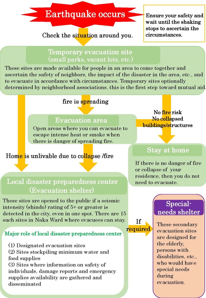
Local Disaster Preparedness Center
Nearby schools will be set up as evacuation centers and temporary shelters to be utilized by people whose homes have been damaged in an earthquake or fire. Post-earthquake evacuation sites ( Local Disaster Preparedness Centers ) stockpile food, beverages, daily necessities, and disaster prevention materials. Emergency supplies will also be sent to these sites in the event of an earthquake.
* Different evacuation sites are opened in the event of heavy winds or flooding.
| Facility Name | Location | Areas covered |
|---|---|---|
| Kitagata ES | Suwa-cho 29 | Yamate-cho 165-171 chome Ueno-cho 1&2 chome, Suwa-cho, Nishinoya-cho, Chiyozaki-cho, Kitagata-cho, Shin-Yamashita 1-3 |
| Motomachi ES | Yamate-cho 36 | Motomachi, Yamate-cho ( except 165-171 ) Ueno-cho 3&4 chome, Kashiwaba, Myokojidai |
| Honcho ES | Hanasaki-cho 3-86 | Akamon-cho 1 chome, Hanabusa-cho, Hatsune-cho, Kogane-cho, Hinode-cho, Sakuragi-cho 1-3 chome, Kaigan-dori, Miyagawa-cho, Motohama-cho Minato-cho chome Sakuragi-cho 1-3 Sumiyoshi-cho Tokiwa-cho Shinko 1&2 chome Masago-cho Aioi-cho Ota-machi Uchida-cho Minaminaka-doru Onoe-cho Benten-dori Kitanaka-dori Noge-cho Hon-cho Nihon-odori Yokohama-Koen |
| Tateno ES | Tateno 76 | Sagiyama, Yamato-cho, Takenomaru, Mugita-cho, Tateno |
| Otori ES | Honmoku-cho 1-251 | Kominato-cho, Hongo-cho, Honmoku-Arai ( 131 132 151 158 170 303 ) Honmoku-Juniten, Honmoku-cho, Honmoku-Manzaka, Honmoku-Midorigaoka, Wadayama |
| Yamamoto ES | Yamamoto-cho 3-152 | Negishidai, Negishi-Asahidai, Yamamoto-cho, Terakubo, Nishi-Takenomaru, Oshibadai, Ohira-cho, Tsukagoshi, Minosawa, Takinoue ( except 51-78 ) |
| Makado ES | Honmoku-Makado 29-1 | Negishi-cho, Chidori-cho, Honmoku-Makado, Honmoku-Arai ( except 131 132 151 158 170 303 ) Honmoku-Sannotani, Honmoku-Osato-cho, Negishi-Kazodai, Ikebukuro |
| Honmoku-Minami ES | Honmoku-Motomachi 44-1 | Kamome-cho, Nishiki-cho, Toyoura-cho, Honmoku-Motomachi, Honmoku-Futo, Minami-Honmoku |
| Honmoku ES | Honmoku-Wada 5-1 | Honmoku-Hara, Honmoku-Wada, Honmoku-Miyabara |
| Minato JS | yamashita-cho 241 | Yamashita-cho |
| Yokohama Yoshida JS | Hagoromo-cho 3-84 | Isezaki-cho, Hagoromo-cho, Yoshida-machi, Wakaba-cho, Akebono-cho, Choja-machi 5-9 chome, Fukutomi-cho-Nishidori, Fukutomi-cho-Nakadori, Fukutomi-cho-Higashidori, Horai-cho Sueyoshi-cho Suehiro-cho Yayoi-cho |
| Minato Sogo HS | Yamashita-cho 231 | Ishikawa-cho, Uchikishi |
| Nakaodai JS | Nakaodai 23 | Takinoue 51-78 Nakaodai, Mameguchidai, Yaguchidai |
| Former Fujimi JS | Yamada-cho 3-9 | chome Okina-cho, Yoshihama-cho, Miyoshi-cho, Yamabuki-cho, Yamada-cho, Kotobuki-cho, Matsukage-cho, Chitose-cho, Ogi-cho, Choja-machi 1-4 Furo-cho Fujimi-cho Bandai-cho |
Kanagawa Labor Plaza | Kotobuki-cho 1-4 | Kotobuki-cho, Ogi-cho, Matuskage-cho, a part of Miyoshi-cho |
Evacuation Area
To protect yourself in the event of a major fire, evacuate to a safety Evacuation Area.
●Evacuation Area Name
・Honmoku-Sancho Koen region
・Negishi Forest Park and Negishi U.S. Naval Housing district
・Minatonomieru-Oka Park
・ Momijigaoka region
・ Nogeyama Park
⇒NAKA-KU Ward Resident Life Activity Map
Evacuating during a tsunami event
Key points to evacuating during a tsunami event
◎Evacuate to higher ground faster
When evacuating, get to a place:
・At least five meters above sea level
・On the third floor or higher of ferroconcrete buildings that can withstand shaking during an earthquake.
◎Do not drive your car to evacuate
Do not evacuate with your car ( except in cases where you are assisting some with difficulty walking or other extraordinary circumstances). กระบวนการ Large numbers of people evacuating by car can cause tariff jams and impede the evacuation
Preparing for heavy rain or typhoon
What to do in the event of heavy rain or typhoon
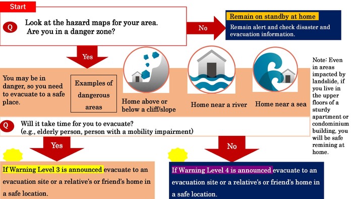
Where do I evacuate?-Evacuate to save your life
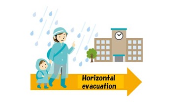
●Evacuate to a safe location
Evacuate to an evacuation site, to nearby high ground, or to the home of a ญาติพี่น้อง in a location not subjected to landslide or potential flood alert.
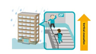
●Evacuate to the second floor or higher of a robust building or to a nearby tall building.
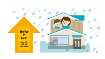
●Take shelter in a safe place inside a building.
If it is more dangerous to evacuate outdoors, instead take shelter on upper floors of your home, the other side of a cliff, etc.
Even when no evacuation ข่าวสาร has been issued, you can take other actions if you feel danger.
Evacuation sites in the event of storm and flooding damage/ warning levels
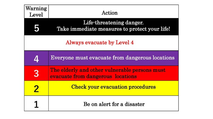
●Warning Level
●Evacuation sites
At Warning Level 3 evacuation sites will be opened for people located near cliffs/slopes, etc.
・Mugita Seifuso : Mugita-cho 1-26-1
・Yamamoto ES: Yamamoto-cho 3-152
・Otori ES: Honmoku-cho 1-251
・Kamidai Shukaijo: Hongo-cho 2-50
・Minato Sogo HS: Yamashita-cho 231
Note: Additional evacuation sites will be opened in accordance with disaster circumstances.
These sites differ แบบ the evacuation shelters that open following an earthquake with a seismic intensity (shindo) of 5+ or higher.
Page ID : 285-365-330